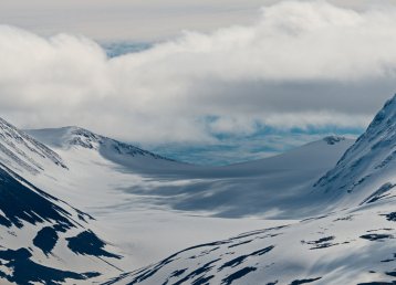
Sweden’s highest point
The first time I climbed Giebmegáisi was in another time, another life. It was in the 90s, and during winter. My friends and I from the Mountain Guide Programme in Storuman ascended it in the spring-winter, taking what’s known as the Eastern Route (Östra leden). At the time, Sweden’s highest peak was still the mountain’s glacier-clad south summit.
These days global warming – the effects of which are most noticeable in the Arctic part of Sweden – has shrunk the glacier on the south summit and the rocky north summit is now Sweden’s highest point with its 2,097.5 metres above sea level. The first time I was up there, in 1990, I was more than 2,114 metres above sea level. Today I’m at least 17 metres lower down, standing on Sweden’s highest mountain. That’s basically a six-storey building that has melted from underneath my feet. It’s difficult to grasp – it’s hard to just dismiss.

The first ascent
The first to set foot on Sweden’s highest mountain were the Frenchman Charles Rabot together with the Norwegians Hans Monsen and Peder Abrahamsson Lindgren, who made it here with the help of Sami guide Jon Larsson. They did this on August 22 in 1883, and Rabot describes it in his book Au Cap Nord. Rabot was actually the secretary of the Geographical Society of Paris, but his book wasn’t published in France until 1898, so his achievement was kept a secret for nearly 15 years. Therefore, teenager Johan Alfred Björling figured he would be the first to reach the summit in the summer of 1889. Björling and a friend also managed to ascend the south summit, taking the Western Route (Västra leden) trail that is often referred to as Björling’s way. So, for some years two Swedish teenagers were credited with the first ascent of Sweden’s highest mountain, when in fact it was a secretive Frenchman.
"The story goes that Rabot climbed to the top wearing nothing but his underpants"
Charles Rabot calculated the elevation of the south summit to be 2,130 metres above sea level. But it’s difficult to say for sure, as no one knows whether Rabot’s measurement instruments were calibrated correctly that very day in 1883. His expedition as such began at Skjommen in Norway, and the hike to the foot of the mountain is said to have taken six days in never-ending rain. Back then it was easier to travel from the Norwegian coast than braving the Swedish Arctic inland. Nowadays it’s very uncomplicated to get here from Nikkaluokta, which is 19 kilometres from the mountain station at the Giebmegáisi massif. The story goes that Rabot climbed to the top wearing nothing but his underpants, as he had to save his one pair of trousers. This is, however, not recommended. Make sure you bring enough clothes.

The disputed name
In Swedish, the name of the mountain became Kebnekaise, a Swedish version of Sami Giebmegáisi. From Lule Sami, the word giebnne is translated as cauldron, or bowl, in English. Gájsse is the word for a high and pointed peak. But as you approach the mountain, by boat from Enok’s in Láddjujávri, the name suddenly seems to make no sense. The only pointed mountain with an eye-catching cauldron at the top is called Duolbagorni according to the Swedish map. Meanwhile, the mountain that’s actually called ‘Cauldron Peak’ just looks like a continuous rock wall without the slightest bowl, or tiny cauldron. You’re probably right in questioning this. The Swedish surveyors, on the other hand, got it all wrong. When they inquired about the name of Sweden’s highest mountain, the Sami guides simply looked at the peak that was the most obvious marker in the landscape and told them ‘Giebmegáisi’. That’s why Sweden’s highest mountain is called ‘Cauldron Peak’ even though it features neither bowl-shapes, nor pointed tops.

The mountain station
The first ascents and geographical expeditions to the area around Giebmegáisi were both strenuous and time consuming. It took a lot of time to get there, and the accommodation offers were limited at best. It’s an easy journey now, whether you opt to hike or to go by helicopter from Nikkaluokta village to the STF mountain station at the foot of the mountain. The first part of the mountain station was built in 1907–08, in the Alpine style with thick stone walls. In the Alps this kept the house cool in summer and warm in winter, but the design in an Arctic setting, where there’s decidedly more winter than summer, basically just created a large fridge. That first constructor was a J. A. Fors from Kiruna, who actually has the first ascent of Kaskasatjåkko, 2,093 m., together with Borg Mesch.
"Even 100 years ago, they understood the importance of treating yourself to the good life when climbing"
Since then, Kebnekaise mountain station has been added to several times and now has a couple of hundred beds as well as a good restaurant. It almost goes without saying that food is important here. Already back in 1889, the yearly magazine published by the Swedish Tourism Association (STF) provided advice on “Laying up Provisions when Mountaineering”. The article said, among other things:
“Based on my experiences and discoveries, I highly favour the following: a couple of slices of chilled roast beef, half of a roasted hen, and black bread (and on occasion, for the sake of variety, two eggs, not too hard boiled). For dessert a piece of premium dry chocolate. To drink, half a bottle of red wine, and half a bottle of champagne.”
It certainly seems like even 100 years ago, they understood the importance of treating yourself to the good life when climbing.

The routes and the climbing
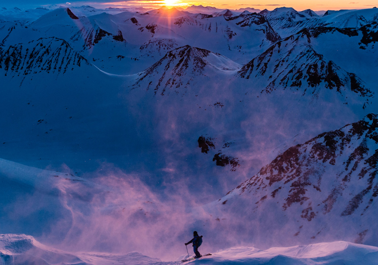
We’ve already mentioned some of the routes on Sweden’s highest peak. So high, they say, that you can see more than 10 per cent of the country from up there. The Western Route, or Björling’s Way, is basically just a long hike from the mountain station, across the intermediate peak Rullevara and on towards the south summit. The Eastern Route, on the other hand, features both a traverse across a glacier and climbing, and is an option offered to guests at the station by mountain guides if you don’t happen to have the necessary experience yourself. Durling’s Route is another option, which starts from the hut Singisstugan and then ascends the valley Kaffedalen where it merges with the Western Route. Durling’s Route lacks exposed and/or steep sections and is more like a long walk uphill. But a massif such as Giebmegáisi also features more exposed, harder climbs for those that way inclined.

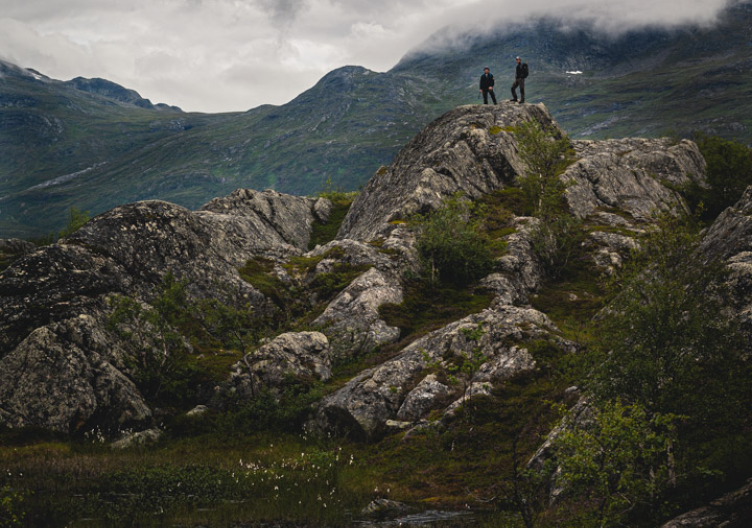
Mountain climbing
Together with Sarek, this is Sweden’s most Alpine setting. There are around 40 glaciers in this area alone. A climbing guide for the area was published in 2019: “Klättring in Kebnekaise” (Climbing in Kebnekaise) by Robin Andersson and Jon Moln Teike. Because nowadays, if you want to ascend the north summit, it takes an exposed walk along the airy ridge from south to north. Something only to be attempted if you have experience – or a guide.
Climbing in the Kebnekaise massif has never been easy. The mountain range, the Scandes, is exposed to the weather and, because of the way the climate affects the mountain, the weather is rarely stable on the Swedish side. Rockfalls are common, and sometimes it can be difficult to find safe belay spots. With that in mind, the achievements of the past are special, the early ascents perhaps even bordering on reckless. With the development of better climbing gear, and the possibility of having things transported, the chance of success on more demanding routes has improved. Also, equipment is lighter, and the quality better. That means that even if you’re not attempting one of the more demanding climbs and just want to hike your way up to the summit along Durling’s Route, good equipment and the right clothes really are a must. This is an exposed environment.
— The most interesting thing as we were working on the climbing guide was everyone’s involvement. Our job is non-profit, but there were so many others who were eager to contribute. It certainly proved how many share a special bond with Giebmegáisi, says Robin Andersson when we meet by the mountain in late summer.

Life on the line
We’ve mentioned photographer Borg Mesch and constructor J. A. Fors. Mesch was also a member of the Lapland Mountain Men’s Club, an almost elitist association that made it clear that climbing was for adventurers. The statutes said that to be accepted you would have to have climbed routes ”with such fury” that the board would consider membership justified. This “fury” was explained as “defined by mortal danger, inevitable injury in the face of adversity … and similar arduous exploits”.
The Mountain Men’s Club was active during that first golden age of Giebmegáisi’s climbing history. From 1920 and a couple of decades onwards several new ascents were made. Not least the first ascent of Kaskasapakte, the really Alpine peak in the area, must be mentioned. During the 40s, some ill-fated accidents took place which may have caused interest in climbing to wane, but during the 60s there was another upswing that saw a lot of new ascents in the area.

The Sarri family
For nearly all those who begin or finish a visit to Keb, as it’s often called, in Nikkaloukta, the Sarri family is part of the journey. Marit Sarri was the manager of the mountain station for a long time, and she’s currently the manager of the stations in the area, including STF’s mountain stations in Abisko and Saltoluokta. Marit’s cousin is called Erik. He runs the snowmobile guest transport to the station in wintertime, and Erik’s sister Anna runs the facility in Nikkaloukta that pretty much everyone visits, here at the end of the road. Another part of the family manage ‘Enoks’ in Ladjujavrre where you can get a boat ride across the lake, but also stay comfortably, and eat well. Sarri is a well-known name to older Swedish readers, because Marit’s uncle Enok used to be a common feature on TV, predicting the weather. I manage to have a chat with Marit on one of the days I was there, asking her about the Sarris and their relationship with Keb.
— I actually grew up in Nikkaluokta and worked as a cabin host and at the station when I was young. Then I thought I’d get away from here, so moved to Uppsala to get an education.
After a few years in Uppsala, she moved back to Kiruna to work as an A&E nurse. When the position as a manager at Kebnekaise mountain station came up, she applied for it.


Mountain entrepreneurs
It was a year of famine, and the dissolution of the union between Sweden and Norway, that led to the Sarris settling in Nikkaluokta. Suddenly reindeer herders weren’t allowed to use their land on the Norwegian side. During a year of famine in the beginning of the 20th century a large part of Nils Olsson Sarri’s reindeer herd died, and Nikka – as he was known – chose to live with his wife Maria on a so-called mountain settlement that was awarded by the state. The small settlement, with various rights attached to it, also saw the first tourists arrive once the railway reached Gällivare and Kiruna. Nikka realised there was some extra money to be made from these visitors by offering a boat service on the Kalix River, and as a guide in the mountains. In the meantime, the family was getting larger. Nikka and Maria had 15 children, one of whom died young, but 14 children grew up on that mountain settlement. Then Maria became a widow quite early and it’s difficult to grasp the hardships they must have endured. However: overcoming adversity is a breeding ground for creativity.
"It's more a home than a job, I think that's what it's like for all of us Sarris"
— Marit Sarri
In 1945 four of the brothers started the company Nikkaluokta Turisttrafik. They provided accommodation and transport for visitors, but also worked with construction and transport of building supplies to the mountain cabins that STF were building in the area along Kungsleden (the King’s Trail) towards Abisko as well as Saltoluokta. In 1972 the road reached Nikkaluokta and in 1989 the facility as we know it was built. In 1995 the brothers retired and that’s when Erik took over the traffic and his sister Anna took over the facility itself, and Marit tried to move, but didn’t succeed.
— No, it’s more a home than a job. I think that’s what it’s like for all of us Sarris. That’s why it’s so important that we know how to manage it.
— During my lifetime, the highest peak in Sweden has become the second highest, with the glacier disappearing. It’s not going to come back at the blink of an eye, that’s for sure. To have a job where I get to take care of all this is important to me. But at the same time it’s my home, that I’m so proud of, and I want to show it to others.

New ascent
My next ascent of Giebmegáisi is only a few hours away. Hopefully. Robin Andersson – the author of the climbing guide – and I are sat in the restaurant talking about the mountain. He’s just descended it. I’m hoping to be able to get up there the next day. The ridge walk between the south and the north peak is an airy experience, so to speak, and you have to have the necessary experience to attempt it. If you don’t, you should only attempt it in the company of a mountain guide from the station. I ask Robin if he has a favourite route to the top. He says:
— Nygren’s Route is something of a favourite. It’s on the sunny side of the mountain, more or less straight on to the north summit. Then you walk across the arête to the south summit and descend along the Eastern Route. It’s a nice round trip.
Even if it’s always an amazing experience to ascend a mountain, with the view and that dizzying feeling almost like magic, it’s strange that the mountain I’m attempting again tomorrow has shrunk the equivalent of a six-storey building since last time. It just isn’t right, and I wish there were something I could do to rectify it. But tomorrow all I can do is carefully place one foot in front of the other. This is, after all, someone else’s home I’m visiting.